
Hydrographic and Offshore Survey Services | Worldwide Survey Dynamics
Worldwide Survey Dynamics specializes in hydrographic and offshore survey services. We offer bathymetric, topographic, and geospatial surveys for marine, coastal, and offshore industries. Our team uses advanced technology, industry-leading software, and high-precision equipment to ensure accurate data collection, processing, and analysis.
Our services support maritime navigation, offshore energy, infrastructure development, and environmental conservation. We follow global standards set by IHO, IMO, FIG, and ISO.
Bathymetric Surveys – High-Resolution Underwater Mapping
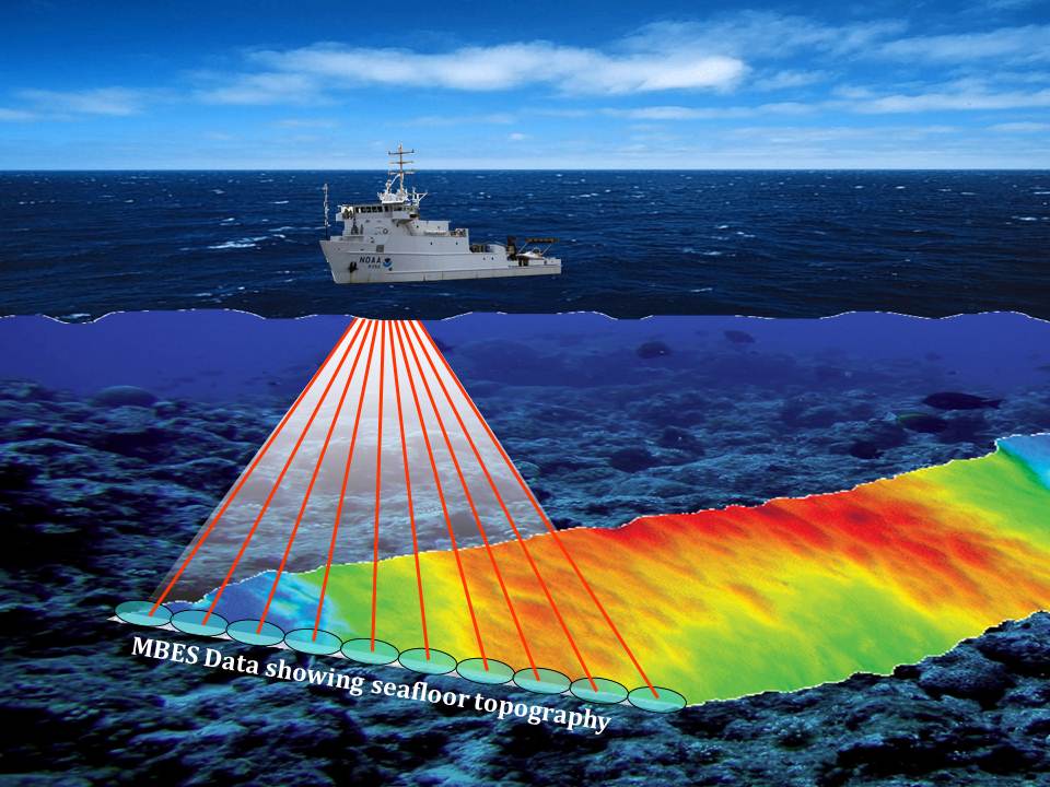
We provide high-resolution bathymetric surveys to measure water depths and underwater terrain. Our surveys support marine navigation, dredging, offshore engineering, and environmental assessments.
– Ensures safe navigation
– Supports dredging & port development
– Helps offshore infrastructure projects
– Assists environmental & habitat assessments
– Aids submarine cable & pipeline planning
Advanced Survey Technology
We use Multibeam and Single-Beam Echosounders, Sub-bottom Profilers, Side-Scan Sonars, GNSS systems, and Motion Sensors for precise underwater data collection.
High-Quality Data Processing
Our team processes data using CARIS HIPS & SIPS, Qimera, EIVA NaviModel, and BeamworX AutoClean to maintain high accuracy.
Read our latest case study on offshore wind farm surveys.
Offshore Surveys – Essential for Energy & Marine Projects
As part of our hydrographic and offshore survey solutions, we provide high-precision offshore surveys to support oil & gas, offshore wind farms, and marine construction. Our services ensure safe and efficient offshore operations by mapping seabed conditions, pipeline routes, and submerged hazards.
Comprehensive Offshore Survey Services
– Seabed mapping for offshore wind farms, oil rigs, and pipelines
– Sub-bottom profiling to analyze seabed composition
– Side-scan sonar surveys to detect underwater structures and hazards
– Positioning & geodetic control for offshore installations
Advanced Survey Technology
We utilize cutting-edge equipment for precise data acquisition:
– AUV & ROV-Based Surveys: Saab Seaeye Falcon, Teledyne Gavia AUV
– Multibeam & Long-Range Sonar: Kongsberg EM2040, Teledyne SeaBat T50-R
– Subsea Positioning Systems: Sonardyne USBL, Kongsberg HiPAP
Industry-Leading Software
Our expert team processes and analyzes data using:
– Seabed Interpretation: OARS, Chesapeake SonarWiz
– 3D Offshore Data Visualization: Fledermaus, QPS Qimera
– Pipeline & Cable Route Planning: EIVA NaviSuite, CARIS BASE Editor
Contact us for more details about our offshore survey solutions.
Hydrographic Data Acquisition & Processing Training – Industry-Standard Skills
We provide professional training in hydrographic and offshore survey solutions, equipping you with industry-standard skills for marine and offshore surveying.
Hydrographic Data Acquisition Training
Gain practical skills in hydrographic survey operations, including:
– Bathymetric & sonar survey fundamentals
– Equipment setup, calibration & data collection
– Survey planning, execution & best practices
Hydrographic Data Processing & Analysis Training
Learn industry-standard software and techniques for processing hydrographic data, covering:
– Multibeam & backscatter processing
– Data cleaning, filtering & quality control
– GIS integration & digital elevation models
With expert-led courses and hands-on training, our program prepares you for a successful career in marine mapping, offshore surveying, and hydrographic data analysis.
Learn more about our hydrographic training programs
Geodetic Control, Positioning & Offshore Vessel Dimension Control
We provide high-precision geodetic control, positioning, and vessel calibration services to support hydrographic and offshore survey solutions for engineering, hydrographic, and offshore projects. Our expertise ensures accurate coordinate systems, real-time positioning, and sensor alignment for seamless survey integration.
Geodetic Control & Positioning Services
– GPS & GNSS-based geodetic surveys
– Coordinate system transformations & benchmarking
– Real-time kinematic (RTK) & post-processed kinematic (PPK) positioning
– Total station surveys for high-accuracy control networks
Hydrographic & Offshore Vessel Dimension Control
– Vessel offset calibration & sensor alignment
– IMU & GNSS system integration for precise positioning
– Multibeam echosounder calibration & validation
Advanced Survey Technology
– GNSS & RTK Systems: Trimble SPS985, Leica Viva GS16
– Total Stations: Leica TS16, Trimble S7
With cutting-edge technology and precise calibration techniques, we ensure accurate geospatial data for marine, offshore, and engineering applications.
Contact us to discuss geodetic control and vessel calibration.